Home
About us
Municipalities
Analytics
News
geo
eng
Home
About us
Municipalities
Analytics
News
contact@geologymaps.ge
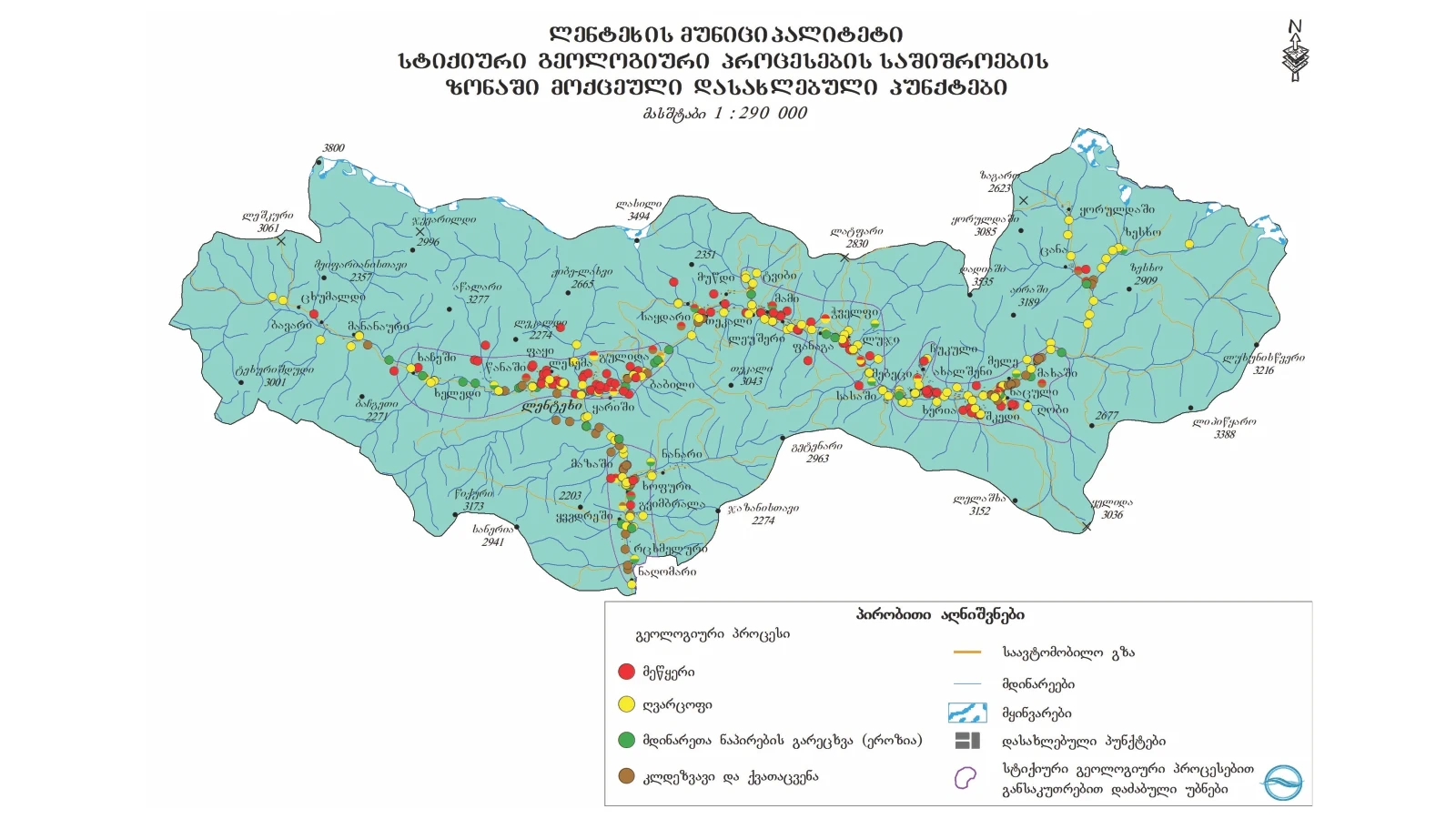
Lentekhi | 40 location
Home
Municipalities
Lentekhi
Geological event
Select a geological event
Abrasion (geologic)
Concave
Flood
Gullying
Landslide
Lateral erosion
Mudslide
Other
Rock avalanche
Rockfall
Washing the river bank
level of danger
Select a risk level
Very high
High
Medium
Low
N/A
Village Paki, left slope of Kheledula river gorge
Geological event:
Landslide
level of danger:
Medium
Village Tsana, the left unnamed tributary of the Kheledula River and the left slope of the Kheledula River
Geological event:
Landslide
level of danger:
High
Village Tsana, the left unnamed tributary of the Kheledula River and the left slope of the Kheledula River
Geological event:
Lateral erosion
level of danger:
High
Village Tsana, the left unnamed tributary of the Kheledula River and the left slope of the Kheledula River
Geological event:
Mudslide
level of danger:
High
Village Lesema, left slope of Kheledula river
Geological event:
Landslide
level of danger:
Medium
Village Lesema, left slope of Kheledula river
Geological event:
Mudslide
level of danger:
Medium
Village Babili, the right slope of the Tskhenistkalii river
Geological event:
Landslide
level of danger:
High
Village Babili, the right slope of the Tskhenistkalii river
Geological event:
Rock avalanche
level of danger:
High
Village Babili, the right slope of the Tskhenistkalii river
Geological event:
Mudslide
level of danger:
High
Village Melura, the right slope of the Tskhenistkalii river
Geological event:
Landslide
level of danger:
Medium
Village Mami v the right slope of the Tskhenistkalii river
Geological event:
Landslide
level of danger:
High
Village Mami v the right slope of the Tskhenistkalii river
Geological event:
Rock avalanche
level of danger:
High
Village Mami v the right slope of the Tskhenistkalii river
Geological event:
Mudslide
level of danger:
High
Village Mele, the right slope of the Tskhenistkalii river
Geological event:
Landslide
level of danger:
Medium
Village Mele, the right slope of the Tskhenistkalii river
Geological event:
Rockfall
level of danger:
Medium
Village Luji, the right slope of the Tskhenistkalii river
Geological event:
Landslide
level of danger:
Medium
Village Luji, the right slope of the Tskhenistkalii river
Geological event:
Mudslide
level of danger:
Medium
Village Chukuli, the right tributary of the Tskhenistkalii river, the right slope of the Fishkori river
Geological event:
Landslide
level of danger:
High
Village Kheleda, Kheledula river valley, left tributary of Tshvareshi river
Geological event:
Mudslide
level of danger:
High
Village Gulida, the right slope of Tskhenistkalii river
Geological event:
Landslide
level of danger:
Medium
Village Mananuri, the left tributary of the Kheledula river, the valley of the Skilari river
Geological event:
Mudslide
level of danger:
Medium
Village Shkedi, the left tributary of the Tskhenistkalii river, the Tskhenshuri river valley
Geological event:
Mudslide
level of danger:
Medium
Village Shkedi, the left tributary of the Tskhenistkalii river, the Tskhenshuri river valley
Geological event:
Lateral erosion
level of danger:
Medium
Town Lentekhi, Kheledula river valley
Geological event:
Mudslide
level of danger:
Medium
Town Lentekhi, Kheledula river valley
Geological event:
Lateral erosion
level of danger:
Medium
Village Makha, right slope of Tskhenistkalii river
Geological event:
Landslide
level of danger:
Medium
Village Khopuri, right slope of Khophuri river
Geological event:
Mudslide
level of danger:
High
Village Khopuri, right slope of Khophuri river
Geological event:
Landslide
level of danger:
High
Village Tvibi, Mukhra valley, right tributary of Tskhenistkalii river
Geological event:
Mudslide
level of danger:
High
Village Tvibi, Mukhra valley, right tributary of Tskhenistkalii river
Geological event:
Lateral erosion
level of danger:
High
Village Rtskhmelura, the right tributary of the Tskhenistkalii River, the left slope of the Chaluri River Gorge
Geological event:
Mudslide
level of danger:
Medium
Village Durashi, the right tributary of the Tskhenistkalii i river, the Cholshuri river valley; Tsiskvilkar river gorge (left tributary of Cholshuri river)
Geological event:
Mudslide
level of danger:
High
Village Durashi, the right tributary of the Tskhenistkalii i river, the Cholshuri river valley; Tsiskvilkar river gorge (left tributary of Cholshuri river)
Geological event:
Lateral erosion
level of danger:
High
Village Sasashiasa, the left tributaries of the Tskhenistkalii river gorge
Geological event:
Mudslide
level of danger:
High
Lentekhi-Koruldashi central highway, tributaries of Tskhenistkalii river; The left slope of Tskhenistkalii river
Geological event:
Mudslide
level of danger:
High
Lentekhi-Koruldashi central highway, tributaries of Tskhenistkalii river; The left slope of Tskhenistkalii river
Geological event:
Lateral erosion
level of danger:
High
Lentekhi-Koruldashi central highway, tributaries of Tskhenistkalii river; The left slope of Tskhenistkalii river
Geological event:
Landslide
level of danger:
High
Lentekhi-Koruldashi central highway, tributaries of Tskhenistkalii river; The left slope of Tskhenistkalii river
Geological event:
Rock avalanche
level of danger:
High
The central highway connecting Tsageri-Lentekhi, the right side of the Tskhenistkalii river,
Geological event:
Lateral erosion
level of danger:
Medium
Village Laskadura, the left tributary of the Laskadura river, the valley of the Lonauri river
Geological event:
Mudslide
level of danger:
Medium
The maps used in the project were produced by the National Environmental Agency.
.png)
.png)
.png)
.png)
.png)
.png)
.png)
.png)
.png)
.png)
.png)
.png)
.png)
.png)
.png)
.png)
.png)
.png)
.png)
.png)
.png)
.png)
.png)
.png)
.png)
.png)
.png)
.png)
.png)
.png)