Home
About us
Municipalities
Analytics
News
geo
eng
Home
About us
Municipalities
Analytics
News
contact@geologymaps.ge
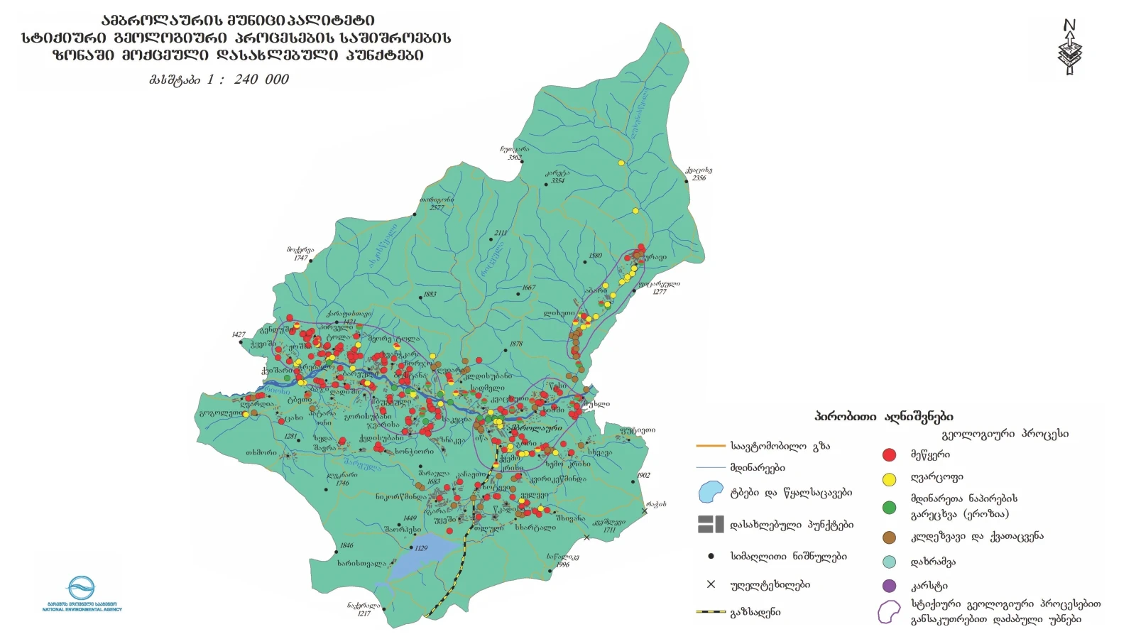
Ambrolauri | 25 location
Home
Municipalities
Ambrolauri
Geological event
Select a geological event
Abrasion (geologic)
Concave
Flood
Gullying
Landslide
Lateral erosion
Mudslide
Other
Rock avalanche
Rockfall
Washing the river bank
level of danger
Select a risk level
Very high
High
Medium
Low
N/A
Baji village, left slope of Rioni river valley
Geological event:
Landslide
level of danger:
High
Kvatskhuti village, right slope of Rioni river gorge
Geological event:
Landslide
level of danger:
High
Village in Gendushi, right tributary of Askistskali River, left slope of Lahsishghele River Gorge
Geological event:
Landslide
level of danger:
High
The village of Lower Tchkvishii, right slope of Rioni river valley
Geological event:
Landslide
level of danger:
High
The village Tsesi, right bank of Rioniriver valley
Geological event:
Landslide
level of danger:
High
The village is Zeda Ghvardia, the right slope of Rioni river
Geological event:
Rock avalanche
level of danger:
High
Kviriketsminda village, left slope of Krikhula river
Geological event:
Landslide
level of danger:
High
Village Pirveli Tola, on the right slope of the Rioni river valley
Geological event:
Landslide
level of danger:
High
Village Meore Tola, the right slope of the valley of the Tolisgheli River, the right tributary of the Rioni River
Geological event:
Landslide
level of danger:
High
Village Chorjo, right slope of Rion river valley
Geological event:
Landslide
level of danger:
Medium
Village Sadmeli,, the right slope of the Rioni river valley
Geological event:
Landslide
level of danger:
Medium
The village of Kvemo Zhoshkha, the lower slope of the Askistkskali river valley
Geological event:
Landslide
level of danger:
High
Ambrolauri city, left slope of Rioni river valley
Geological event:
Landslide
level of danger:
Medium
Village Uravi, , right slope of Lukhuniskali river valley
Geological event:
Landslide
level of danger:
High
Village Uravi, , right slope of Lukhuniskali river valley
Geological event:
Mudslide
level of danger:
High
Dzirageuli village, right slope of Rioniriver valley
Geological event:
Landslide
level of danger:
Medium
Dzirageuli village, right slope of Rioniriver valley
Geological event:
Mudslide
level of danger:
Medium
Kedisubani village, the upper part of the slope of the left northern exposure of Rioni River
Geological event:
Landslide
level of danger:
Medium
Chrebalo village, right slope of Rioni river valley
Geological event:
Landslide
level of danger:
Medium
Chrebalo village, right slope of Rioni river valley
Geological event:
Mudslide
level of danger:
Medium
Khotevi village, left slope of Khoteura river
Geological event:
Landslide
level of danger:
High
Village Mukhli, , the right slope of the valley of the river Sakori (the left tributary of the river Rion).
Geological event:
Landslide
level of danger:
High
Tsesi-Urav Central highway
Geological event:
Rockfall
level of danger:
Medium
Chrebalo-Nikortsminda central highway
Geological event:
Landslide
level of danger:
Medium
Chrebalo-Nikortsminda central highway
Geological event:
Lateral erosion
level of danger:
Medium
The maps used in the project were produced by the National Environmental Agency.
.png)
.png)
.png)
.png)
.png)
.png)
.png)
.png)
.png)
.png)
.png)
.png)
.png)
.png)
.png)
.png)
.png)
.png)
.png)
.png)
.png)
.png)