Home
About us
Municipalities
Analytics
News
geo
eng
Home
About us
Municipalities
Analytics
News
contact@geologymaps.ge
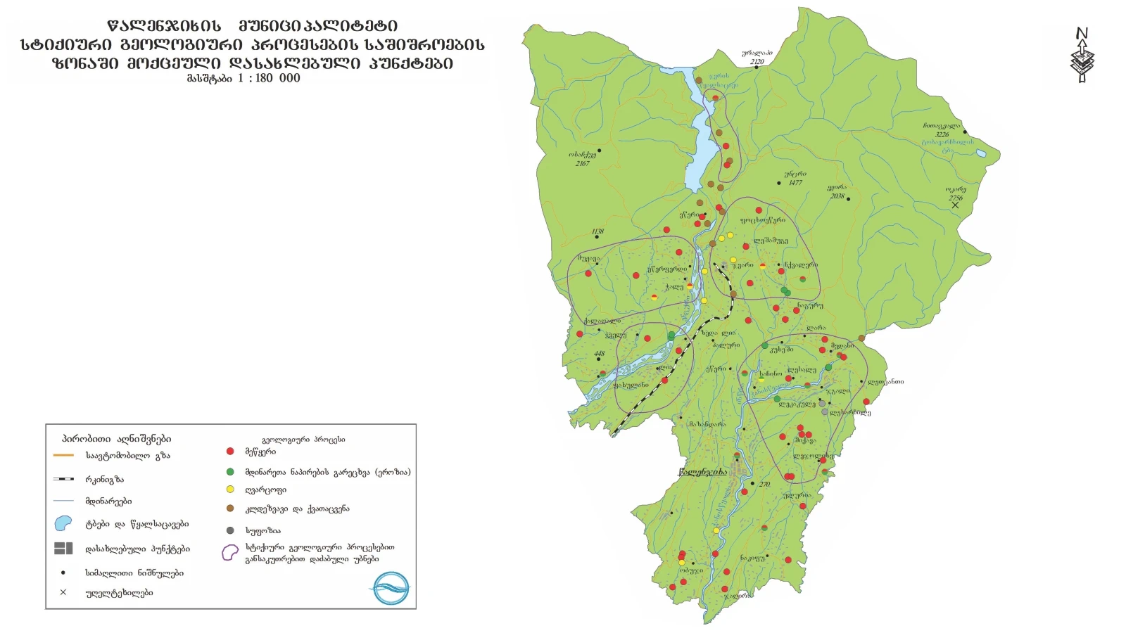
Tsalenjikha | 36 location
Home
Municipalities
Tsalenjikha
Geological event
Select a geological event
Abrasion (geologic)
Concave
Flood
Gullying
Landslide
Lateral erosion
Mudslide
Other
Rock avalanche
Rockfall
Washing the river bank
level of danger
Select a risk level
Very high
High
Medium
Low
N/A
43th Kilometer of Zugdidi -Mestia Central Highway
Geological event:
Rock avalanche
level of danger:
High
43th Kilometer of Zugdidi -Mestia Central Highway
Geological event:
Landslide
level of danger:
High
Village Obuji
Geological event:
Landslide
level of danger:
High
Village Obuji, Torchia River Gorge
Geological event:
Landslide
level of danger:
High
The left slope of the Enguri river valley. the so-called "Khoko Landslide"
Geological event:
Landslide
level of danger:
High
Village Lia
Geological event:
Landslide
level of danger:
Medium
Village Pakhulani
Geological event:
Landslide
level of danger:
High
Village Tchvele
Geological event:
Landslide
level of danger:
High
Village Muzhava
Geological event:
Landslide
level of danger:
High
Village Muzhava
Geological event:
Landslide
level of danger:
Medium
Village Muzhava
Geological event:
Landslide
level of danger:
High
Village Muzhava
Geological event:
Landslide
level of danger:
High
Village Chkvaleri
Geological event:
Landslide
level of danger:
High
Chkvaleri village, the left slope of the Morizha river valley, near the school
Geological event:
Landslide
level of danger:
High
The Centre of the village Medani
Geological event:
Landslide
level of danger:
High
Leshamuge village, right slope of Morizha river gorge
Geological event:
Landslide
level of danger:
High
Jaghira village, the left slope of Tchanistskali river valley
Geological event:
Landslide
level of danger:
High
Jaghira village
Geological event:
Landslide
level of danger:
High
Lecarde village, left unnamed tributary of the Magana River
Geological event:
Mudslide
level of danger:
Medium
Lecarde village, left unnamed tributary of the Magana River
Geological event:
Mudslide
level of danger:
High
Town Djvari, The left unnamed tributory of the River Enguri
Geological event:
Mudslide
level of danger:
Medium
South of the Town Djvari, River Okharkale
Geological event:
Mudslide
level of danger:
Medium
Village Etseri
Geological event:
Landslide
level of danger:
Medium
Village Tchale da Village Etserferdi
Geological event:
Mudslide
level of danger:
Medium
Village Naguru
Geological event:
Landslide
level of danger:
High
Village Mikava
Geological event:
Landslide
level of danger:
High
Nearby teritory of Village Mikava
Geological event:
Landslide
level of danger:
Medium
Zugdidi-Jvari-Mestia-Laslidi Motorway
Geological event:
Landslide
level of danger:
Medium
Zugdidi-Jvari-Mestia-Laslidi Motorway
Geological event:
Rock avalanche
level of danger:
Medium
Zugdidi-Jvari-Mestia-Laslidi Motorway. The right slope of the river Magana
Geological event:
Rockfall
level of danger:
Medium
Zugdidi-Jvari-Mestia-Laslidi Motorway. The left slope of the river Enguri
Geological event:
Rockfall
level of danger:
Medium
Zugdidi-Jvari-Mestia-Laslidi Motorway. The left slope of the river Enguri
Geological event:
Rockfall
level of danger:
Medium
Zugdidi-Jvari-Mestia-Laslidi Motorway. The right slope of the river Magana
Geological event:
Rockfall
level of danger:
Medium
The right slope of the river Magana
Geological event:
Rockfall
level of danger:
Medium
The road leading to the "Engurhesi" dam, the right slope of the Enguri river valley
Geological event:
Rockfall
level of danger:
Medium
The right slope of the river Magana
Geological event:
Rockfall
level of danger:
Medium
The maps used in the project were produced by the National Environmental Agency.
.png)
.png)
.png)
.png)
.png)
.png)
.png)
.png)
.png)
.png)
.png)
.png)
.png)
.png)
.png)
.png)
.png)
.png)
.png)
.png)
.png)
.png)
.png)
.png)
.png)
.png)
.png)
.png)
.png)
.png)
.png)
.png)
.png)
.png)
.png)